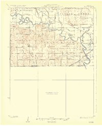
1924 Map of Hale
USGS Topo · Published 1924About this map
The meandering Grand River dominates this northern Missouri landscape, carving a complex path through the corners of Livingston, Carroll, Linn, and Chariton counties. In this era, the river plain is defined by oxbow lakes like Custer Lake, Fish Lake, and Eagle Lake, signaling a dynamic riparian environment before modern channelization. The local economy and social fabric are anchored by a dense network of country schoolhouses, such as Elk Grove School, Progressive School, and Asper School, alongside gathering places like Grace Church.
Find a feature on this map
54 named features on this map. Tap any name to fly to it.
Don’t see what you’re looking for? This feature index may not catch every label — zoom into the map to look around manually.
Map Details
Editions of this 1924 Hale Map
4 editions found
Other maps of this area

1889 · Lexington
USGS Topo · 1:125,000

1890 · Marshall
USGS Topo · 1:125,000

1892 · Marshall
USGS Topo · 1:125,000

1901 · Marshall
USGS Topo · 1:125,000

1921 · Chillicothe
USGS Topo · 1:62,500

1923 · Chillicothe
USGS Topo · 1:62,500

1924 · Dawn
USGS Topo · 1:62,500

1924 · Chula
USGS Topo · 1:62,500

1924 · Hale
USGS Topo · 1:62,500

1946 · Brookfield
USGS Topo · 1:62,500