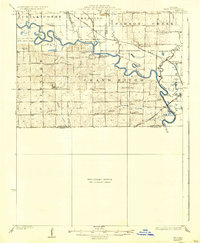
1924 Map of Hale
USGS Topo · Published 1937About this map
The Grand River carves a meandering path across this North Missouri landscape, defining the rural character of southeastern Livingston County and its neighbors. In the early 1920s, the region was a dense network of small school districts and country parishes, with local life centered around points like Avalon and Bedford. The map reveals a sophisticated transport system of the era, where the Wabash and Chicago Burlington and Quincy railroads intersected the river-fed terrain. Of particular interest to family historians are the numerous named schoolhouses, such as Morgan School, Asper School, and Hazel Green School, which served as the primary social anchors for the surrounding farmsteads. Near the confluence of the Grand and the Chariton River, the Sumner Ferry provides evidence of river crossings that persisted even as rail and improved roads began to dominate the Missouri interior.
Find a feature on this map
56 named features on this map. Tap any name to fly to it.
Don’t see what you’re looking for? This feature index may not catch every label — zoom into the map to look around manually.
Map Details
Editions of this 1924 Hale Map
4 editions found
Other maps of this area

1889 · Lexington
USGS Topo · 1:125,000

1890 · Marshall
USGS Topo · 1:125,000

1892 · Marshall
USGS Topo · 1:125,000

1901 · Marshall
USGS Topo · 1:125,000

1921 · Chillicothe
USGS Topo · 1:62,500

1923 · Chillicothe
USGS Topo · 1:62,500

1924 · Dawn
USGS Topo · 1:62,500

1924 · Chula
USGS Topo · 1:62,500

1924 · Hale
USGS Topo · 1:62,500

1946 · Brookfield
USGS Topo · 1:62,500