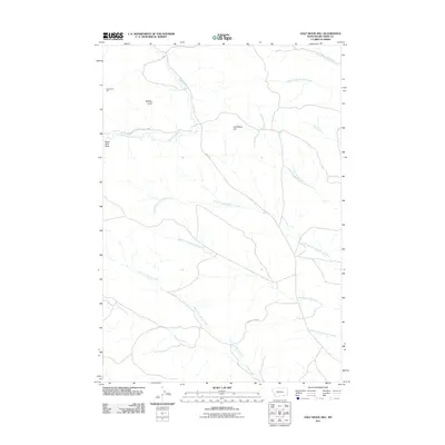
2011 Map of Half Moon Hill
USGS Topo · Published 2011About this map
Rosebud Battlefield State Park preserves the grounds of a significant historical conflict within this Big Horn County landscape. The terrain is defined by distinct landmarks such as Buffalo Jump and Monument Hill, which reflect the area's deep indigenous and frontier heritage. Rosebud Creek flows through the northern reaches, joined by a dense network of drainages including Leaf Rock Creek and Post Creek. The map details a predominantly rural expanse where transportation is limited to routes like Kirby Rd and County Rd-305, serving a landscape of high ridges like Eagle Nest Peak and Half Moon Hill. This survey captures the topographical complexity of the region before modern development, focusing on the natural drainages of the North Fork Spring Creek and South Fork Monument Creek systems.
Find a feature on this map
17 named features on this map. Tap any name to fly to it.
Don’t see what you’re looking for? This feature index may not catch every label — zoom into the map to look around manually.
Map Details
Editions of this 2011 Half Moon Hill Map
This is the sole edition of this map. No revisions or reprints were ever made.
Other maps of this area

1894 · Rosebud
USGS Topo · 1:125,000

1901 · Rosebud
USGS Topo · 1:125,000

1954 · Hardin
USGS Topo · 1:250,000

1957 · Hardin
USGS Topo · 1:250,000

1958 · Hardin
USGS Topo · 1:250,000

1967 · Tongue River Dam
USGS Topo · 1:24,000

1967 · Kirby
USGS Topo · 1:24,000

1967 · Bar V Ranch NE
USGS Topo · 1:24,000
1967 · Bar V Ranch
USGS Topo · 1:24,000
1967 · Pearl School
USGS Topo · 1:24,000