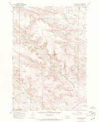
1967 Map of Pearl School
USGS Topo · Published 1971About this map
Pearl Sch and the small settlement of Decker anchor this remote landscape in Big Horn County during the late 1960s. The terrain is defined by a complex network of drainage and irrigation, centered around Squirrel Creek and the Tongue R. The presence of several major water-management features, including the Cormack Ditch, Powers Cormack Ditch, and Powers Brothers Ditch, highlights the region's reliance on managed water for agriculture and ranching in a dry climate. A lonely Landing Strip and a Drill Hole suggest the varied economic activities of the era, from aviation-supported ranching to resource exploration. Named tributaries like Pearson Creek, Pond Creek, and Youngs Creek carve through the topography, illustrating the natural watershed before reaching the larger river system. This survey documents the intersection of rural education, family-scale irrigation engineering, and the quiet persistence of small Montana communities.
Find a feature on this map
20 named features on this map. Tap any name to fly to it.
Don’t see what you’re looking for? This feature index may not catch every label — zoom into the map to look around manually.
Map Details
Editions of this 1967 Pearl School Map
This is the sole edition of this map. No revisions or reprints were ever made.
Other maps of this area

1894 · Rosebud
USGS Topo · 1:125,000

1895 · Dayton
USGS Topo · 1:125,000

1901 · Rosebud
USGS Topo · 1:125,000

1901 · Dayton
USGS Topo · 1:125,000

1909 · Sheridan
USGS Topo · 1:125,000

1911 · Sheridan
USGS Topo · 1:125,000

1954 · Hardin
USGS Topo · 1:250,000

1955 · Sheridan
USGS Topo · 1:250,000

1957 · Hardin
USGS Topo · 1:250,000

1958 · Hardin
USGS Topo · 1:250,000