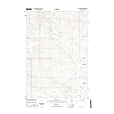
2017 Map of Half Moon Hill
USGS Topo · Published 2017About this map
Buffalo Jump serves as a prominent landmark in this corner of Big Horn County, marking a landscape defined by significant elevation changes and seasonal watercourses. The terrain is characterized by high points like Eagle Nest Peak and Half Moon Hill, which overlook a complex drainage system including Rosebud Cr and the various forks of Leaf Rock Cr and N Fork Monument Cr. This 2017 survey reflects the modern infrastructure of the region, where ranching and resource extraction roads such as Co RD 314, Hamilton Rd, and Spring Creek Mine Rd thread through the hills. The presence of a named buffalo jump provides a direct link to the indigenous history and hunting practices that long preceded the current road network and township divisions.
Find a feature on this map
24 named features on this map. Tap any name to fly to it.
Don’t see what you’re looking for? This feature index may not catch every label — zoom into the map to look around manually.
Map Details
Editions of this 2017 Half Moon Hill Map
This is the sole edition of this map. No revisions or reprints were ever made.
Other maps of this area

1894 · Rosebud
USGS Topo · 1:125,000

1901 · Rosebud
USGS Topo · 1:125,000

1954 · Hardin
USGS Topo · 1:250,000

1957 · Hardin
USGS Topo · 1:250,000

1958 · Hardin
USGS Topo · 1:250,000

1967 · Tongue River Dam
USGS Topo · 1:24,000

1967 · Kirby
USGS Topo · 1:24,000

1967 · Bar V Ranch NE
USGS Topo · 1:24,000
1967 · Bar V Ranch
USGS Topo · 1:24,000
1967 · Pearl School
USGS Topo · 1:24,000