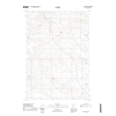
2020 Map of Half Moon Hill
USGS Topo · Published 2020About this map
Buffalo Jump stands as a prominent landmark in this portion of the Big Horn Basin, marking a landscape defined by significant topographic relief and intermittent water sources. The map Detail centers on a complex network of drainages including Rosebud Cr, Leaf Rock Cr, and N Fork Monument Cr, which carve through the high plains. Elevation reaches its peak at Eagle Nest Peak and the namesake Half Moon Hill in the northern half of the quadrangle. The presence of numerous named springs, such as 07S39E10BCAC01 Spring and 08S39E16ADCA01 Spring, indicates the critical role of groundwater in this arid Montana environment. Transportation is limited to a few secondary routes, including Montana Secondary Highway 566 and Spring Creek Mine Rd, reflecting the area's rural and likely industrial or agricultural character.
Find a feature on this map
40 named features on this map. Tap any name to fly to it.
Don’t see what you’re looking for? This feature index may not catch every label — zoom into the map to look around manually.
Map Details
Editions of this 2020 Half Moon Hill Map
This is the sole edition of this map. No revisions or reprints were ever made.
Other maps of this area

1894 · Rosebud
USGS Topo · 1:125,000

1901 · Rosebud
USGS Topo · 1:125,000

1954 · Hardin
USGS Topo · 1:250,000

1957 · Hardin
USGS Topo · 1:250,000

1958 · Hardin
USGS Topo · 1:250,000

1967 · Tongue River Dam
USGS Topo · 1:24,000

1967 · Kirby
USGS Topo · 1:24,000

1967 · Bar V Ranch NE
USGS Topo · 1:24,000
1967 · Bar V Ranch
USGS Topo · 1:24,000
1967 · Pearl School
USGS Topo · 1:24,000