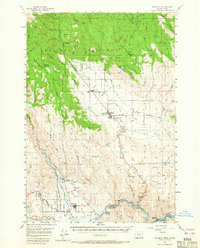
1957 Map of Halfway
USGS Topo · Published 1965About this map
The confluence of the Snake River and Powder River defines this landscape in Eastern Oregon, where the agricultural flats of Eagle Valley meet the timbered slopes of the Whitman National Forest. This mid-century survey captures the region just before the waters of the Brownlee Dam would submerge portions of the shoreline near Robinette. The town of Halfway serves as a central hub, surrounded by smaller settlements like New Bridge, Richland, and Carson.
Find a feature on this map
55 named features on this map. Tap any name to fly to it.
Don’t see what you’re looking for? This feature index may not catch every label — zoom into the map to look around manually.
Map Details
Editions of this 1957 Halfway Map
2 editions found
Other maps of this area

1915 · Pine
USGS Topo · 1:125,000

1954 · Cornucopia
USGS Topo · 1:62,500

1954 · Eagle Cap
USGS Topo · 1:62,500

1955 · Baker
USGS Topo · 1:250,000

1955 · Grangeville
USGS Topo · 1:250,000

1957 · Halfway
USGS Topo · 1:62,500

1957 · Homestead
USGS Topo · 1:62,500

1957 · Copperfield
USGS Topo · 1:62,500

1957 · Sparta
USGS Topo · 1:62,500

1957 · Sturgill Peak
USGS Topo · 1:62,500