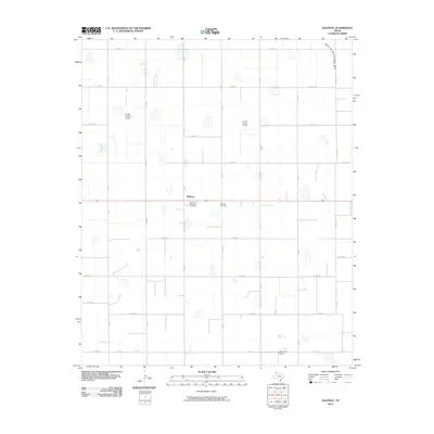
2010 Map of Halfway
USGS Topo · Published 2010About this map
Halfway serves as the central hub for this agricultural landscape on the High Plains, where a geometric grid of county roads defines the territory. The map reveals an area deeply integrated with aviation and research, featuring private airstrips such as Buddy Harmel Airport, Smith Farms Airport, and Laney Farm Airport interspersed among the fields. The presence of the High Plains Research Foundation near the town center underscores the region's commitment to agricultural advancement. Apart from the local commerce, the terrain is marked by seasonal hydrology, most notably the North Fork Running Water Draw in the northeast and numerous small depression ponds or playas scattered across the sections. Genealogists and local historians can pinpoint family-centered locations through the Halfway Cemetery and the many named farm roads that structure the rural community.
Find a feature on this map
27 named features on this map. Tap any name to fly to it.
Don’t see what you’re looking for? This feature index may not catch every label — zoom into the map to look around manually.
Map Details
Editions of this 2010 Halfway Map
This is the sole edition of this map. No revisions or reprints were ever made.
Other maps of this area

1954 · Plainview
USGS Topo · 1:250,000

1954 · Clovis
USGS Topo · 1:250,000

1958 · Clovis
USGS Topo · 1:250,000

1958 · Plainview
USGS Topo · 1:250,000

1965 · Kress West
USGS Topo · 1:24,000

1965 · Edmonson
USGS Topo · 1:24,000

1965 · Hilburn
USGS Topo · 1:24,000

1965 · Wasson
USGS Topo · 1:24,000

1968 · Halfway
USGS Topo · 1:24,000
1968 · Hale Center SW
USGS Topo · 1:24,000