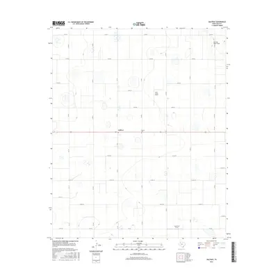
2016 Map of Halfway
USGS Topo · Published 2016About this map
Halfway serves as a central point in this high-plains landscape of Hale County, defined by a rigid grid of agricultural roads and scattered playa-like depressions. The rural character of the area is underscored by the presence of private aviation facilities like Smith Farms Airport and Laney Farm Airport, which dot the expansive landscape alongside numerous farm-to-market routes. Running Water Draw provides the primary topographic variation in the northeast corner, cutting across the otherwise level terrain. Genealogists and local historians will find the Halfway Cem situated just east of the main settlement, a quiet landmark in a region dominated by large-scale farming operations. The layout of county roads, such as Co RD 70 and Co RD 100, reflects a highly organized land-use pattern typical of the Texas Panhandle during this mid-2010s period.
Find a feature on this map
25 named features on this map. Tap any name to fly to it.
Don’t see what you’re looking for? This feature index may not catch every label — zoom into the map to look around manually.
Map Details
Editions of this 2016 Halfway Map
This is the sole edition of this map. No revisions or reprints were ever made.
Other maps of this area

1954 · Plainview
USGS Topo · 1:250,000

1954 · Clovis
USGS Topo · 1:250,000

1958 · Clovis
USGS Topo · 1:250,000

1958 · Plainview
USGS Topo · 1:250,000

1965 · Kress West
USGS Topo · 1:24,000

1965 · Edmonson
USGS Topo · 1:24,000

1965 · Hilburn
USGS Topo · 1:24,000

1965 · Wasson
USGS Topo · 1:24,000

1968 · Halfway
USGS Topo · 1:24,000
1968 · Hale Center SW
USGS Topo · 1:24,000