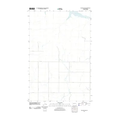
2011 Map of Halliday NW
USGS Topo · Published 2011About this map
Lake Sakakawea defines the northern reaches of this Dunn County landscape, where the Missouri River's waters meet the prairie. The terrain is characterized by the winding paths of North Creek and Steel Creek, which carve through the rural expanse south of the reservoir. A rigid grid of section-line roads, including 91st Ave SW, 89th Ave SW, and 88th Ave SW, provides access to the agricultural hinterlands. The presence of Main St and several numbered streets like 1st St NW and 1st St SW indicates the local transportation framework connecting the sparse homesteads of the Twin Buttes area. This survey documents the intersection of modern infrastructure and the expansive water systems that dominate western North Dakota.
Find a feature on this map
11 named features on this map. Tap any name to fly to it.
Don’t see what you’re looking for? This feature index may not catch every label — zoom into the map to look around manually.
Map Details
Editions of this 2011 Halliday NW Map
This is the sole edition of this map. No revisions or reprints were ever made.
Other maps of this area

1953 · Watford City
USGS Topo · 1:250,000

1957 · Watford City
USGS Topo · 1:250,000

1967 · Watford City
USGS Topo · 1:250,000

1970 · Halliday NE
USGS Topo · 1:24,000

1970 · Hay Flat
USGS Topo · 1:24,000

1970 · Halliday NW
USGS Topo · 1:24,000

1970 · Dunn Center NE
USGS Topo · 1:24,000

1970 · Mandaree SE
USGS Topo · 1:24,000
1970 · Saddle Butte SW
USGS Topo · 1:24,000

1973 · Halliday
USGS Topo · 1:24,000