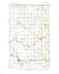
1941 Map of Hallock
USGS Topo · Published 1941About this map
Hallock serves as the focal point of this Kittson County landscape, situated where the Great Northern railroad and the meandering Two Rivers converge. The agricultural character of the Red River Valley is evident through a dense network of country schoolhouses, such as Grasshopper Sch, West Granville Sch, and Mayflower Sch, which were spaced to serve family farms just before mid-century consolidation. Northward, the Minneapolis St Paul and Sault Ste Marie rail line cuts diagonally through Orleans and Lancaster, facilitating the movement of grain and timber across the international border. Beyond the town sites, landmarks like the Country Club near the river and the Oak View Cem near Northcote provide specific points of interest for genealogists tracing early twentieth-century settlers in townships like Richardville and Thompson.
Find a feature on this map
44 named features on this map. Tap any name to fly to it.
Don’t see what you’re looking for? This feature index may not catch every label — zoom into the map to look around manually.
Map Details
Editions of this 1941 Hallock Map
3 editions found
Other maps of this area

1918 · Hemmington
USGS Topo · 1:62,500

1939 · Drayton
USGS Topo · 1:62,500

1939 · Pembina
USGS Topo · 1:62,500

1939 · Kennedy
USGS Topo · 1:62,500

1941 · Kennedy
USGS Topo · 1:62,500

1941 · Drayton
USGS Topo · 1:62,500

1941 · Hallock
USGS Topo · 1:62,500

1941 · Pembina
USGS Topo · 1:62,500

1952 · Thief River Falls
USGS Topo · 1:250,000

1956 · Thief River Falls
USGS Topo · 1:250,000