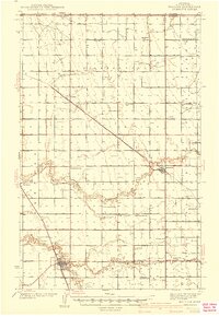
1941 Map of Hallock
USGS Topo · Published 1941About this map
Hallock serves as the focal point of this Red River Valley landscape, situated at the confluence of the South Branch and the main channel of Two Rivers. The 1941 topography reveals a strictly organized agricultural grid across townships like Richardville and Clow, where the reliance on water management is evident through extensive drainage projects like State Ditch No 84 and Judicial Ditch No 31.
Find a feature on this map
33 named features on this map. Tap any name to fly to it.
Don’t see what you’re looking for? This feature index may not catch every label — zoom into the map to look around manually.
Map Details
Editions of this 1941 Hallock Map
3 editions found
Other maps of this area

1918 · Hemmington
USGS Topo · 1:62,500

1939 · Drayton
USGS Topo · 1:62,500

1939 · Pembina
USGS Topo · 1:62,500

1939 · Kennedy
USGS Topo · 1:62,500

1941 · Kennedy
USGS Topo · 1:62,500

1941 · Drayton
USGS Topo · 1:62,500

1941 · Hallock
USGS Topo · 1:62,500

1941 · Pembina
USGS Topo · 1:62,500

1952 · Thief River Falls
USGS Topo · 1:250,000

1956 · Thief River Falls
USGS Topo · 1:250,000