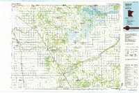
1985 Map of Hallock
USGS Topo · Published 1985About this map
The Burlington Northern railroad corridor anchors the Red River Valley landscape in this mid-1980s look at northwestern Minnesota. Stretching along the international border with Canada, the region is defined by a dense network of water management features including State Ditch No 1 and Judicial Ditch No 32, which drain the flat agricultural plains into the North Branch Two Rivers and Joe River. Large-scale conservation is evident in the sprawling Roseau River State Wildlife Management Area and Lake Bronson State Park, while the local aviation history of the era is captured through numerous private airstrips such as the Nelson Sugden Landing Strip and Lukes Landing Strip. Small prairie towns like Hallock, Lancaster, and Karlstad serve as hubs for this borderland community, situated amidst unique terrain markers like Joppenbury Ridge and Moose Point.
Find a feature on this map
76 named features on this map. Tap any name to fly to it.
Don’t see what you’re looking for? This feature index may not catch every label — zoom into the map to look around manually.
Map Details
Editions of this 1985 Hallock Map
2 editions found
Other maps of this area

1918 · Hemmington
USGS Topo · 1:62,500

1918 · Rollis
USGS Topo · 1:62,500

1918 · Roseau
USGS Topo · 1:62,500

1918 · Acton
USGS Topo · 1:62,500

1918 · Garland
USGS Topo · 1:62,500

1918 · Argyle
USGS Topo · 1:62,500

1918 · Greenbush
USGS Topo · 1:62,500

1918 · Middle River
USGS Topo · 1:62,500

1919 · Pelan
USGS Topo · 1:62,500

1919 · Badger
USGS Topo · 1:62,500