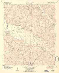
1951 Map of Halltown
USGS Topo · Published 1951About this map
The Illinois Central railroad cuts through the southern terrain of Franklin County, Alabama, connecting the town of Vina to the broader regional economy. This mid-century survey illustrates a landscape defined by the Tennessee Valley and the Divide, where small communities like Halltown and Burntout are linked by a network of rural roads such as the Old Cotton Gin Road. Local genealogy is well-preserved through numerous family-named landmarks, including Weatherbee Cem, Gober Cem, and the Liberty Hill Church.
Find a feature on this map
66 named features on this map. Tap any name to fly to it.
Don’t see what you’re looking for? This feature index may not catch every label — zoom into the map to look around manually.
Map Details
Editions of this 1951 Halltown Map
2 editions found
Other maps of this area

1925 · Barton
USGS Topo · 1:62,500

1926 · Barton
USGS Topo · 1:48,000

1929 · Barton
USGS Topo · 1:62,500

1935 · Pleasant Site
USGS Topo · 1:24,000

1936 · Belmont
USGS Topo · 1:24,000

1936 · Pleasant Grove
USGS Topo · 1:24,000

1936 · Hodges
USGS Topo · 1:24,000

1936 · Red Bay
USGS Topo · 1:24,000

1936 · Vina
USGS Topo · 1:24,000

1936 · Halltown
USGS Topo · 1:24,000