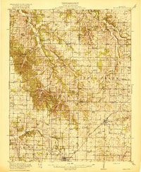
1919 Map of Halltown
USGS Topo · Published 1919About this map
Paris Springs and Halltown anchor this southwestern Missouri landscape during a time when rural education was localized to dozens of neighborhood schools. The survey reveals a dense network of one-room schoolhouses, such as Tiede School, Blades School, and Buck Prairie School, each serving its respective township. The St Louis San Francisco railroad cuts through the southern reaches, connecting Billings and Logan to the wider regional economy.
Find a feature on this map
75 named features on this map. Tap any name to fly to it.
Don’t see what you’re looking for? This feature index may not catch every label — zoom into the map to look around manually.
Map Details
Editions of this 1919 Halltown Map
3 editions found
Other maps of this area

1884 · Springfield
USGS Topo · 1:125,000

1886 · Greenfield
USGS Topo · 1:125,000

1886 · Springfield
USGS Topo · 1:125,000

1888 · Greenfield
USGS Topo · 1:125,000

1907 · Forsyth
USGS Topo · 1:125,000

1919 · Halltown
USGS Topo · 1:62,500

1921 · Stotts City
USGS Topo · 1:62,500

1936 · Brookline
USGS Topo · 1:24,000

1942 · Aurora
USGS Topo · 1:62,500

1943 · Monett
USGS Topo · 1:62,500