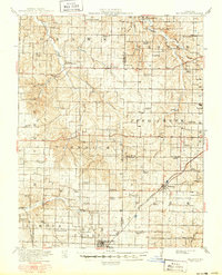
1919 Map of Halltown
USGS Topo · Published 1950About this map
Halltown and its surrounding townships in Lawrence County appear here during a transition from early pioneer settlement to an established agricultural and transit hub. The landscape is defined by the winding course of Turnback Creek and its many tributaries, such as Pickerel Creek and Honey Creek. The density of rural education is a striking feature of this era, with dozens of local schools like St Elmo School, France Valley School, and Lick Prairie School serving small clusters of families before mid-century consolidation.
Find a feature on this map
73 named features on this map. Tap any name to fly to it.
Don’t see what you’re looking for? This feature index may not catch every label — zoom into the map to look around manually.
Map Details
Editions of this 1919 Halltown Map
3 editions found
Other maps of this area

1884 · Springfield
USGS Topo · 1:125,000

1886 · Greenfield
USGS Topo · 1:125,000

1886 · Springfield
USGS Topo · 1:125,000

1888 · Greenfield
USGS Topo · 1:125,000

1907 · Forsyth
USGS Topo · 1:125,000

1919 · Halltown
USGS Topo · 1:62,500

1921 · Stotts City
USGS Topo · 1:62,500

1936 · Brookline
USGS Topo · 1:24,000

1942 · Aurora
USGS Topo · 1:62,500

1943 · Monett
USGS Topo · 1:62,500