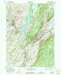
1954 Map of Hamburg
USGS Topo · Published 1990About this map
The Wallkill River and Papakating Creek converge in this Sussex County landscape, shaping a corridor for both nature and industry in the mid-1950s. The region is defined by the heavy presence of the Lehigh And New England railroad, which weaves through settlements like Sussex, Hamburg, and Franklin. The map captures a transition in transportation, showing both active rail lines and an Old Railroad Grade near McAfee. Industrial activity is evident in the numerous Quarries dotting the base of the Hamburg Mountains, while local civic life is anchored by landmarks such as the Township Sch and Sussex Airport. For genealogists, the map is particularly rich, identifying several burial grounds including Wantage Cem, Fairview Cem, and the Immaculate Conception Cem, providing a precise spatial record of the community's heritage during a period of stability before later suburban expansion.
Find a feature on this map
53 named features on this map. Tap any name to fly to it.
Don’t see what you’re looking for? This feature index may not catch every label — zoom into the map to look around manually.
Map Details
Editions of this 1954 Hamburg Map
4 editions found
Other maps of this area

1888 · Franklin
USGS Topo · 1:62,500

1891 · Greenwood Lake
USGS Topo · 1:62,500

1893 · Greenwood Lake
USGS Topo · 1:62,500

1894 · Franklin
USGS Topo · 1:62,500

1897 · Franklin
USGS Topo · 1:62,500

1903 · Franklin Furnace
USGS Topo · 1:62,500

1903 · Greenwood Lake
USGS Topo · 1:62,500

1906 · Port Jervis
USGS Topo · 1:62,500

1906 · Goshen
USGS Topo · 1:62,500

1908 · Goshen
USGS Topo · 1:62,500
Featured Places
- Vernon Township, NJ
- Wantage, NJ
- Wantage Township, Vernon Township
- Franklin, Hardyston Township
- Hamburg, Hardyston Township