
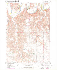
1952 Map of Hamill NW
USGS Topo · Published 1954About this map
The Rosebud Indian Reservation occupies the southern half of this mid-century landscape, where the land transitions from the high prairie into the breaks of the White River. This area along the Tripp and Lyman County border reflects a traditional ranching economy of the early 1950s, defined by isolated homesteads such as the Schooler Ranch, Nelson Ranch, and Fenenga Ranch. The drainage patterns of No Moccasin Creek and Thunder Creek dictate the placement of local infrastructure, including small rural education centers like Gassman Sch and Bellwood Sch. This survey, produced for the development of the Missouri River Basin, provides a detailed look at the land use and topographic relief of the Bailey region before modern agricultural shifts altered the footprint of these historic South Dakota ranching tracts.
Find a feature on this map
16 named features on this map. Tap any name to fly to it.
Don’t see what you’re looking for? This feature index may not catch every label — zoom into the map to look around manually.
Map Details
Editions of this 1952 Hamill NW Map
2 editions found
Other maps of this area

1951 · Ideal NE
USGS Topo · 1:24,000

1952 · Reliance SW
USGS Topo · 1:24,000

1952 · Reliance SE
USGS Topo · 1:24,000

1952 · Hamill NE
USGS Topo · 1:24,000

1955 · Mitchell
USGS Topo · 1:250,000

1959 · Mitchell
USGS Topo · 1:250,000

1971 · Hamill SE
USGS Topo · 1:24,000

1971 · Hamill
USGS Topo · 1:24,000
1978 · Kennebec SE
USGS Topo · 1:24,000

1982 · King Dam
USGS Topo · 1:25,000