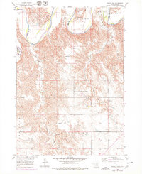
1952 Map of Hamill NW
USGS Topo · Published 1979About this map
The White River carves a deep, winding path through the northern half of this South Dakota landscape, marking the natural boundary between Tripp and Lyman counties. While the northern terrain is defined by the river’s floodplain and the elevations of Bailey, the southern portion transitions into the rolling hills of Roseland. Water is the lifeblood of this prairie region, as seen in the numerous drainage systems including No Moccasin Creek, Black Dog Creek, and Moccasin Creek. Human presence is sparse and centered on the cattle industry and local education, evidenced by the scattered Schooler Ranch, Nelson Ranch, and the Gassman Sch. A Flowing Well in the center of the sheet indicates the reliance on subterranean water sources in this mid-century agricultural environment.
Find a feature on this map
12 named features on this map. Tap any name to fly to it.
Don’t see what you’re looking for? This feature index may not catch every label — zoom into the map to look around manually.
Map Details
Editions of this 1952 Hamill NW Map
2 editions found
Other maps of this area

1951 · Ideal NE
USGS Topo · 1:24,000

1952 · Reliance SW
USGS Topo · 1:24,000

1952 · Reliance SE
USGS Topo · 1:24,000

1952 · Hamill NW
USGS Topo · 1:24,000

1952 · Hamill NE
USGS Topo · 1:24,000

1955 · Mitchell
USGS Topo · 1:250,000

1959 · Mitchell
USGS Topo · 1:250,000

1971 · Hamill SE
USGS Topo · 1:24,000

1971 · Hamill
USGS Topo · 1:24,000
1978 · Kennebec SE
USGS Topo · 1:24,000