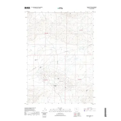
2017 Map of Hamilton Dome
USGS Topo · Published 2017About this map
Hamilton Dome and Owl Creek define this Hot Springs County landscape, where industrial activity and ranching roots meet the varied topography of the Bighorn Basin. The map details a complex network of access roads, such as Hamilton Dome Rd and Cottonwood Creek Rd, serving the local oil fields and agricultural interests. Drainage patterns are shaped by several seasonal waterways, including Wagonhound Cr, Cottonwood Cr, and Prospect Cr, which flow through distinct geological formations. Significant landmarks like the Legend Rocks petroglyph site and the elevated Wagonhound Bench provide geographical orientation. Modern infrastructure is represented by the Wales Reservoir, while the surrounding terrain is marked by the Ilo Ridge to the north and the Gumbo Hills to the southeast, illustrating the intersection of natural landforms and human development in this part of Wyoming.
Find a feature on this map
17 named features on this map. Tap any name to fly to it.
Don’t see what you’re looking for? This feature index may not catch every label — zoom into the map to look around manually.
Map Details
Editions of this 2017 Hamilton Dome Map
This is the sole edition of this map. No revisions or reprints were ever made.
Other maps of this area

1913 · Grass Creek Basin
USGS Topo · 1:62,500

1914 · Blue Mesa
USGS Topo · 1:62,500

1915 · Grass Creek Basin
USGS Topo · 1:62,500

1916 · Blue Mesa
USGS Topo · 1:62,500

1955 · Thermopolis
USGS Topo · 1:250,000

1958 · Thermopolis
USGS Topo · 1:250,000

1962 · Thermopolis
USGS Topo · 1:250,000

1965 · Arapahoe Ranch
USGS Topo · 1:24,000
1965 · Embar
USGS Topo · 1:24,000
1965 · Thompson Reservoirs
USGS Topo · 1:24,000