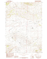
1985 Map of Hamilton Dome
USGS Topo · Published 1985About this map
Hamilton Dome serves as the industrial and settlement hub of this mid-1980s landscape, situated directly within a sprawling Oil Field. This energy production zone is deeply integrated into the arid terrain of the Wind River Indian Reservation, where natural drainage patterns like Wagonhound Creek and Cottonwood Creek cut through the rugged topography. The presence of specialized water management features such as Wales Reservoir and the uniquely named Lake Charlie highlights the intensive land use required for resource extraction in this high-desert environment.
Find a feature on this map
16 named features on this map. Tap any name to fly to it.
Don’t see what you’re looking for? This feature index may not catch every label — zoom into the map to look around manually.
Map Details
Editions of this 1985 Hamilton Dome Map
This is the sole edition of this map. No revisions or reprints were ever made.
Other maps of this area

1913 · Grass Creek Basin
USGS Topo · 1:62,500

1914 · Blue Mesa
USGS Topo · 1:62,500

1915 · Grass Creek Basin
USGS Topo · 1:62,500

1916 · Blue Mesa
USGS Topo · 1:62,500

1955 · Thermopolis
USGS Topo · 1:250,000

1958 · Thermopolis
USGS Topo · 1:250,000

1962 · Thermopolis
USGS Topo · 1:250,000

1965 · Arapahoe Ranch
USGS Topo · 1:24,000
1965 · Embar
USGS Topo · 1:24,000
1965 · Thompson Reservoirs
USGS Topo · 1:24,000