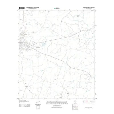
2012 Map of Hamilton East
USGS Topo · Published 2012About this map
The city of Hamilton serves as the focal point of this Central Texas landscape, where residential streets like Eidson and Francis Rd meet the rural outskirts. Local heritage is preserved at the Oak Wood Cem and the uniquely named New Independent Order of Odd Fellows Cem near the town center. The terrain is defined by the winding course of the Leon River and its numerous tributaries, including Pecan Cr and Mustang Cr, which drain the area surrounding landmarks such as Cheyenne Mesa and Dooley Mtn. To the south, the small settlements of Blue Ridge and Aleman reflect the agricultural character of the county. Aviation infrastructure is surprisingly present with both Muxworthy Airport and Yacht Club Airport situated just east of the city, while Saint Pauls School provides a community anchor in the southern reach.
Find a feature on this map
62 named features on this map. Tap any name to fly to it.
Don’t see what you’re looking for? This feature index may not catch every label — zoom into the map to look around manually.
Map Details
Editions of this 2012 Hamilton East Map
This is the sole edition of this map. No revisions or reprints were ever made.
Other maps of this area

1888 · Hamilton
USGS Topo · 1:125,000

1888 · Meridian
USGS Topo · 1:125,000

1894 · Hamilton
USGS Topo · 1:125,000

1894 · Meridian
USGS Topo · 1:125,000

1954 · Brownwood
USGS Topo · 1:250,000

1954 · Waco
USGS Topo · 1:250,000

1955 · Waco
USGS Topo · 1:250,000
1956 · Jonesboro
USGS Topo · 1:24,000

1956 · Gentrys Mill
USGS Topo · 1:24,000
1956 · Ohio
USGS Topo · 1:24,000