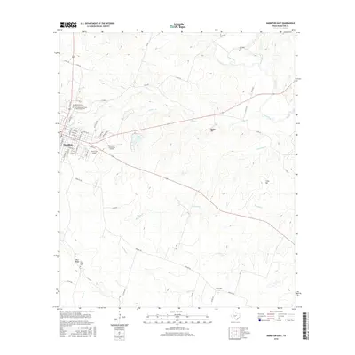
2016 Map of Hamilton East
USGS Topo · Published 2016About this map
The county seat of Hamilton serves as the focal point for this survey, showcasing a grid of residential and commercial streets situated west of Pecan Cr. To the east, the landscape is defined by the winding course of the Leon River and its numerous tributaries, including Twomile Cr and Alexander Cr. Significant local landmarks include the Oak Wood Cem and the uniquely named New Independent Order of Odd Fellows Cem, reflecting the community's early fraternal and social history. The southern portions of the map reveal the smaller settlements of Aleman and Blue Ridge, the latter being near the Blue Ridge Cem. Distinctive elevations like Cheyenne Mesa, Dooley Mtn, and Craig Hill punctuate the terrain. Local transportation and aviation are represented by the presence of Muxworthy Airport and Yacht Club Airport just outside the main township.
Find a feature on this map
66 named features on this map. Tap any name to fly to it.
Don’t see what you’re looking for? This feature index may not catch every label — zoom into the map to look around manually.
Map Details
Editions of this 2016 Hamilton East Map
This is the sole edition of this map. No revisions or reprints were ever made.
Other maps of this area

1888 · Hamilton
USGS Topo · 1:125,000

1888 · Meridian
USGS Topo · 1:125,000

1894 · Hamilton
USGS Topo · 1:125,000

1894 · Meridian
USGS Topo · 1:125,000

1954 · Brownwood
USGS Topo · 1:250,000

1954 · Waco
USGS Topo · 1:250,000

1955 · Waco
USGS Topo · 1:250,000
1956 · Jonesboro
USGS Topo · 1:24,000

1956 · Gentrys Mill
USGS Topo · 1:24,000
1956 · Ohio
USGS Topo · 1:24,000