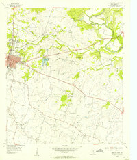
1956 Map of Hamilton East
USGS Topo · Published 1957About this map
Hamilton serves as the central hub of this mid-1950s survey, showing its growth along the 36th Division Memorial Highway. The town's infrastructure is visible through landmarks like Kuykendall Stadium and Oak Wood Cem, while the surrounding landscape is defined by the winding Leon River and several smaller tributaries including Pecan Creek and Alexander Creek.
Find a feature on this map
37 named features on this map. Tap any name to fly to it.
Don’t see what you’re looking for? This feature index may not catch every label — zoom into the map to look around manually.
Map Details
Editions of this 1956 Hamilton East Map
This is the sole edition of this map. No revisions or reprints were ever made.
Other maps of this area

1888 · Hamilton
USGS Topo · 1:125,000

1888 · Meridian
USGS Topo · 1:125,000

1894 · Hamilton
USGS Topo · 1:125,000

1894 · Meridian
USGS Topo · 1:125,000

1954 · Brownwood
USGS Topo · 1:250,000

1954 · Waco
USGS Topo · 1:250,000

1955 · Waco
USGS Topo · 1:250,000
1956 · Jonesboro
USGS Topo · 1:24,000

1956 · Gentrys Mill
USGS Topo · 1:24,000
1956 · Ohio
USGS Topo · 1:24,000