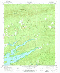
1972 Map of Hamilton
USGS Topo · Published 1974About this map
Ouachita National Forest dominates this section of Garland County, where the topography is defined by the high ridges of Ouachita Mountain and Mill Creek Mountain. In the early 1970s, the southern portion of the quadrangle is submerged beneath the expansive Lake Ouachita, maintained at Elevation 578. This man-made reservoir transformed the local landscape, creating the jagged shoreline that now hosts the Lena Landing Recreational Area and Lake Ouachita State Park. On the higher ground north of the lake, evidence of rural community life persists at Hamilton and the Walnut Grove Ch near the Rock Springs Cem. The presence of a Lookout Tower atop Ouachita Pinnacle and a major Pipeline cutting through the forest reflects the region's 20th-century focus on resource management and infrastructure within the rugged Ouachita interior.
Find a feature on this map
26 named features on this map. Tap any name to fly to it.
Don’t see what you’re looking for? This feature index may not catch every label — zoom into the map to look around manually.
Map Details
Editions of this 1972 Hamilton Map
2 editions found
Other maps of this area

1890 · Hot Springs
USGS Topo · 1:125,000

1894 · Hot Springs
USGS Topo · 1:125,000

1955 · Little Rock
USGS Topo · 1:250,000

1956 · Little Rock
USGS Topo · 1:250,000

1960 · Little Rock
USGS Topo · 1:250,000

1962 · Crystal Springs
USGS Topo · 1:24,000

1962 · Avant
USGS Topo · 1:24,000

1964 · Little Rock
USGS Topo · 1:250,000
1966 · Hot Springs North
USGS Topo · 1:24,000
1966 · Mountain Pine
USGS Topo · 1:24,000