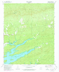
1972 Map of Hamilton
USGS Topo · Published 1977About this map
Lake Ouachita dominates the southern half of this landscape, its complex shoreline reaching into the valleys of Moccasin Creek and Fisher Creek. The map documents a rugged section of the Ouachita National Forest during the early 1970s, where high ridges like Blue Mountain and Mill Creek Mountain rise above the reservoir. For genealogists, the map preserves the locations of several community landmarks, including Rock Springs Ch and the adjacent Rock Springs Cem, alongside Walnut Grove Ch.
Find a feature on this map
26 named features on this map. Tap any name to fly to it.
Don’t see what you’re looking for? This feature index may not catch every label — zoom into the map to look around manually.
Map Details
Editions of this 1972 Hamilton Map
2 editions found
Other maps of this area

1890 · Hot Springs
USGS Topo · 1:125,000

1894 · Hot Springs
USGS Topo · 1:125,000

1955 · Little Rock
USGS Topo · 1:250,000

1956 · Little Rock
USGS Topo · 1:250,000

1960 · Little Rock
USGS Topo · 1:250,000

1962 · Crystal Springs
USGS Topo · 1:24,000

1962 · Avant
USGS Topo · 1:24,000

1964 · Little Rock
USGS Topo · 1:250,000
1966 · Hot Springs North
USGS Topo · 1:24,000
1966 · Mountain Pine
USGS Topo · 1:24,000