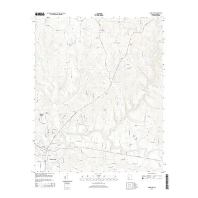
2014 Map of Hamilton
USGS Topo · Published 2014About this map
The Buttahatchee River meanders through the heart of this Marion County landscape, defining the topography around the city of Hamilton. This 2014 survey captures a community deeply rooted in its local geography, with numerous family and community burial grounds such as Cox Family Cem, Streetman Cem, and Poplar Log Cem scattered across the hillsides. The convergence of major transit routes like Us-43 and Us-278 in Hamilton marks the town as a regional hub, while smaller settlements like Pleasant Ridge maintain a quieter character to the west. Farther north, the terrain becomes more varied near landmarks like State Rock and the drainage of Rideout Br. Genealogists will find significant value in the distribution of these cemeteries, including Shiloh Cem and Mt Hope Cem, which serve as physical anchors for the area's historical family names and early rural congregations.
Find a feature on this map
121 named features on this map. Tap any name to fly to it.
Don’t see what you’re looking for? This feature index may not catch every label — zoom into the map to look around manually.
Map Details
Editions of this 2014 Hamilton Map
This is the sole edition of this map. No revisions or reprints were ever made.
Other maps of this area

1936 · Hodges
USGS Topo · 1:24,000

1936 · South Of Hackleburg
USGS Topo · 1:24,000

1936 · Hackleburg
USGS Topo · 1:24,000

1936 · Vina
USGS Topo · 1:24,000

1946 · Hackleburg
USGS Topo · 1:24,000
1948 · Hackleburg
USGS Topo · 1:24,000

1949 · Hodges
USGS Topo · 1:24,000

1950 · Vina
USGS Topo · 1:24,000

1951 · Vina
USGS Topo · 1:24,000

1956 · Gadsden
USGS Topo · 1:250,000