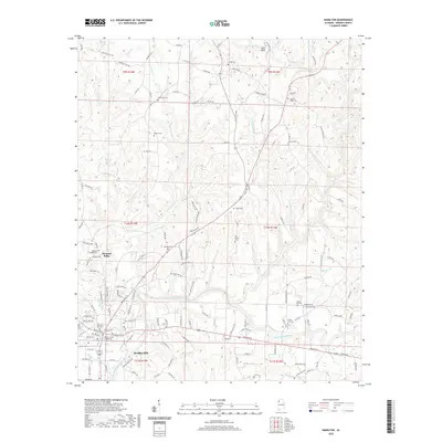
2020 Map of Hamilton
USGS Topo · Published 2020About this map
Hamilton serves as the focal point of this Northwest Alabama survey, anchored by the Marion County Courthouse near the banks of the Buttahatchee River. The settlement pattern follows a mix of established town grids and winding country routes like 1st Military Rd, reflecting the area's transition from river-bottom lands to the higher terrain marked by State Rock. Genealogists will find a high density of rural burial grounds throughout the quadrangle, including the Cox Family Cem, Antioch Cem, and Streetman Cem. North of town, the community of Pleasant Ridge sits amidst a network of creek drainages such as Williams Cr and Clifty Cr. The map preserves the specific locations of historic family and community landmarks, from Mount Hope Cem to Shiloh Cem, illustrating the deep-rooted social geography of Marion County.
Find a feature on this map
147 named features on this map. Tap any name to fly to it.
Don’t see what you’re looking for? This feature index may not catch every label — zoom into the map to look around manually.
Map Details
Editions of this 2020 Hamilton Map
This is the sole edition of this map. No revisions or reprints were ever made.
Other maps of this area

1936 · Hodges
USGS Topo · 1:24,000

1936 · South Of Hackleburg
USGS Topo · 1:24,000

1936 · Hackleburg
USGS Topo · 1:24,000

1936 · Vina
USGS Topo · 1:24,000

1946 · Hackleburg
USGS Topo · 1:24,000
1948 · Hackleburg
USGS Topo · 1:24,000

1949 · Hodges
USGS Topo · 1:24,000

1950 · Vina
USGS Topo · 1:24,000

1951 · Vina
USGS Topo · 1:24,000

1956 · Gadsden
USGS Topo · 1:250,000