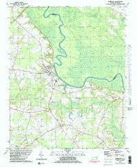
1981 Map of Hamilton
USGS Topo · Published 1981About this map
The Roanoke River snakes through the lowlands of Martin County and Bertie County, defining a landscape where the river’s floodplain dominates the eastern half of the area. On the higher ground to the west, the town of Hamilton serves as the primary settlement, supported by a network of rural communities like Huskanaw and Ballard. This 1981 edition shows the intersection of agricultural life and the marshy wilderness of the Broadneck Swamp and Huskanaw Swamp. The social fabric of these small communities is anchored by numerous country churches, including Spring Green Ch, Cedar Grove Ch, and Lynch Chapel. Education and infrastructure are represented by the Edna Andrews Sch and the municipal Sewage Disposal facility. For the local historian, the map preserves the exact locations of many small family and community cemeteries, simply labeled Cem, alongside winding watercourses like Conoho Creek and Indian Creek.
Find a feature on this map
23 named features on this map. Tap any name to fly to it.
Don’t see what you’re looking for? This feature index may not catch every label — zoom into the map to look around manually.
Map Details
Editions of this 1981 Hamilton Map
2 editions found
Other maps of this area

1901 · Parmele
USGS Topo · 1:62,500

1901 · Williamston
USGS Topo · 1:62,500

1902 · Williamston
USGS Topo · 1:62,500

1902 · Parmele
USGS Topo · 1:62,500

1953 · Norfolk
USGS Topo · 1:250,000

1953 · Rocky Mount
USGS Topo · 1:250,000

1954 · Rocky Mount
USGS Topo · 1:250,000

1962 · Palmyra
USGS Topo · 1:24,000

1972 · Republican
USGS Topo · 1:24,000

1972 · Woodville
USGS Topo · 1:24,000