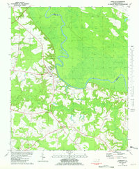
1981 Map of Hamilton
USGS Topo · Published 1981About this map
The Roanoke River carves a sharp, meandering path through the heart of the landscape here, defining the boundary between Bertie Co and Martin Co. This region is characterized by a complex network of wetlands, including Broadneck Swamp and Town Swamp, which likely influenced the historical pattern of settlement on the higher ground of the river’s southern banks. The town of Hamilton serves as the primary hub, where local infrastructure such as the Edna Andrews Sch and a Boat Ramp indicate a community tied to the river. Genealogists and local historians will find an exceptional density of country churches and small burial grounds scattered throughout the rural outskirts, from Lynch Chapel in the west to Chapel Hill Ch and Cedar Grove Ch further south. Smaller settlements like Huskanaw and Ballard anchor the agricultural and wooded interior south of Conoho Creek.
Find a feature on this map
21 named features on this map. Tap any name to fly to it.
Don’t see what you’re looking for? This feature index may not catch every label — zoom into the map to look around manually.
Map Details
Editions of this 1981 Hamilton Map
2 editions found
Other maps of this area

1901 · Parmele
USGS Topo · 1:62,500

1901 · Williamston
USGS Topo · 1:62,500

1902 · Williamston
USGS Topo · 1:62,500

1902 · Parmele
USGS Topo · 1:62,500

1953 · Norfolk
USGS Topo · 1:250,000

1953 · Rocky Mount
USGS Topo · 1:250,000

1954 · Rocky Mount
USGS Topo · 1:250,000

1962 · Palmyra
USGS Topo · 1:24,000

1972 · Republican
USGS Topo · 1:24,000

1972 · Woodville
USGS Topo · 1:24,000