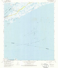
1968 Map of Hammock Lake
USGS Topo · Published 1969About this map
Cypremort Point Beach and the small settlement of Quintana anchor this late 1960s coastal survey at the intersection of Vermilion Bay and West Cote Blanche Bay. The landscape is dominated by a complex network of marshlands and tidal waters, including Hammock Lake, Prince Lake, and the meandering Shark Bayou. These wetlands are vital to the region's ecology and industry, as evidenced by the large Russell Sage Foundation-Marsh Island State Wildlife Refuge and the extensive West Cote Blanche Bay Oil and Gas Field offshore.
Find a feature on this map
23 named features on this map. Tap any name to fly to it.
Don’t see what you’re looking for? This feature index may not catch every label — zoom into the map to look around manually.
Map Details
Editions of this 1968 Hammock Lake Map
2 editions found
Other maps of this area

1932 · Bayou Blanc
USGS Topo · 1:31,680

1937 · Bayou Sale
USGS Topo · 1:62,500

1937 · Jeanerette
USGS Topo · 1:62,500

1937 · Derouen
USGS Topo · 1:62,500

1945 · New Orleans
USGS Topo · 1:250,000
1948 · Bayou Blanc
USGS Topo · 1:24,000

1948 · Cypremort Point
USGS Topo · 1:24,000

1949 · Cypremort Pt
USGS Topo · 1:31,680

1949 · Bayou Lucien
USGS Topo · 1:31,680
1951 · Lake Point
USGS Topo · 1:24,000