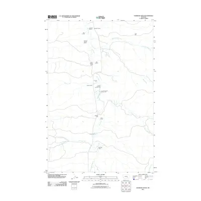
2011 Map of Hammond Ranch
USGS Topo · Published 2011About this map
Tullock Creek serves as the central drainage for this section of Treasure County, carving a path through a landscape defined by expansive flats and deep coulees. The ranching heritage of the region is evident in the presence of Hammond Ranch and Redding Ranch, both situated near the vital water source of the creek. To manage the sparse water resources for livestock and agriculture, infrastructure such as the B and A Hammond Number 1 Dam and B and A Hammond Number 2 Dam were established along the creek bed.
Find a feature on this map
23 named features on this map. Tap any name to fly to it.
Don’t see what you’re looking for? This feature index may not catch every label — zoom into the map to look around manually.
Map Details
Editions of this 2011 Hammond Ranch Map
This is the sole edition of this map. No revisions or reprints were ever made.
Other maps of this area

1954 · Hardin
USGS Topo · 1:250,000

1954 · Forsyth
USGS Topo · 1:250,000

1957 · Hardin
USGS Topo · 1:250,000

1957 · Forsyth
USGS Topo · 1:250,000

1958 · Forsyth
USGS Topo · 1:250,000

1958 · Hardin
USGS Topo · 1:250,000

1960 · Marsh Coulee
USGS Topo · 1:24,000

1960 · Hope Ranch
USGS Topo · 1:24,000
1972 · The Dugout
USGS Topo · 1:24,000

1972 · Hammond Ranch
USGS Topo · 1:24,000