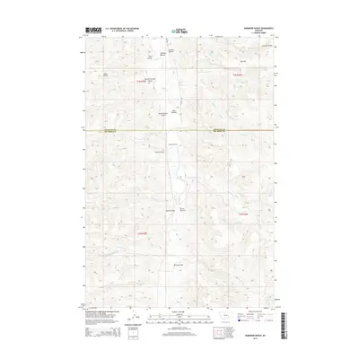
2014 Map of Hammond Ranch
USGS Topo · Published 2014About this map
Hammond Ranch serves as a central landmark in this landscape defined by the drainage of Tullock Creek as it flows northward through the Big Horn and Treasure County line. The terrain is characterized by a series of low-lying areas known as bottoms, including Sullinger Bottom, Bird Bottom, and Turner Bottom, which suggest fertile grounds near the water's edge. This 2014 survey reveals a ranching geography where water sources are vital, highlighted by the location of Kendrick Spring and Summer Springs. The area is deeply dissected by numerous named coulees and draws such as Schrites Coulee, Smith Coulee, and Sawmill Draw, reflecting a complex network of seasonal drainage. While Tullock Rd provides the primary transit route, the map illustrates the persistence of traditional land names like McCurdy Draw and Gass Flat in this portion of Montana.
Find a feature on this map
27 named features on this map. Tap any name to fly to it.
Don’t see what you’re looking for? This feature index may not catch every label — zoom into the map to look around manually.
Map Details
Editions of this 2014 Hammond Ranch Map
This is the sole edition of this map. No revisions or reprints were ever made.
Other maps of this area

1954 · Hardin
USGS Topo · 1:250,000

1954 · Forsyth
USGS Topo · 1:250,000

1957 · Hardin
USGS Topo · 1:250,000

1957 · Forsyth
USGS Topo · 1:250,000

1958 · Forsyth
USGS Topo · 1:250,000

1958 · Hardin
USGS Topo · 1:250,000

1960 · Marsh Coulee
USGS Topo · 1:24,000

1960 · Hope Ranch
USGS Topo · 1:24,000
1972 · The Dugout
USGS Topo · 1:24,000

1972 · Hammond Ranch
USGS Topo · 1:24,000