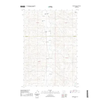
2020 Map of Hammond Ranch
USGS Topo · Published 2020About this map
Hammond Ranch serves as a primary landmark in this ranching landscape where Treasure County meets Big Horn County. The terrain is defined by a dense network of coulees and draws that feed into the valley of Tullock Creek, including the descriptively named Horse Pasture Coulee and Smith Coulee. Large alluvial flats, known locally as bottoms, provide the most significant level ground for operations, specifically at Bird Bottom, Turner Bottom, and Sullinger Bottom. Historically informed place names such as Sawmill Draw and McCurdy Draw suggest the varied economic activities and family legacies that have shaped these drainage basins. These waterways, including Cottonwood Creek and Rough Creek, carve deep into the plateau, creating the distinct topographic character typical of the Montana plains.
Find a feature on this map
27 named features on this map. Tap any name to fly to it.
Don’t see what you’re looking for? This feature index may not catch every label — zoom into the map to look around manually.
Map Details
Editions of this 2020 Hammond Ranch Map
This is the sole edition of this map. No revisions or reprints were ever made.
Other maps of this area

1954 · Hardin
USGS Topo · 1:250,000

1954 · Forsyth
USGS Topo · 1:250,000

1957 · Hardin
USGS Topo · 1:250,000

1957 · Forsyth
USGS Topo · 1:250,000

1958 · Forsyth
USGS Topo · 1:250,000

1958 · Hardin
USGS Topo · 1:250,000

1960 · Marsh Coulee
USGS Topo · 1:24,000

1960 · Hope Ranch
USGS Topo · 1:24,000
1972 · The Dugout
USGS Topo · 1:24,000

1972 · Hammond Ranch
USGS Topo · 1:24,000