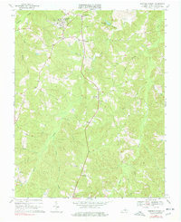
1968 Map of Hampden Sydney
USGS Topo · Published 1978About this map
The prestigious campus of Hampden-Sydney College anchors the northern portion of this Prince Edward County landscape during the late 1960s. The settlement pattern follows the ridge lines between the deeply incised drainages of the Bush River and Buffalo Creek, with small communities like Kingsville and Worsham situated along the historic roadway corridors. The map captures a traditional Piedmont Virginia landscape where institutional history and rural life meet, evidenced by the proximity of the Seminary Cem to the college grounds.
Find a feature on this map
29 named features on this map. Tap any name to fly to it.
Don’t see what you’re looking for? This feature index may not catch every label — zoom into the map to look around manually.
Map Details
Editions of this 1968 Hampden Sydney Map
Other maps of this area

1891 · Farmville
USGS Topo · 1:125,000

1892 · Appomattox
USGS Topo · 1:125,000

1893 · Farmville
USGS Topo · 1:125,000

1947 · Roanoke
USGS Topo · 1:250,000

1956 · Charlotte Court House
USGS Topo · 1:62,500

1958 · Farmville
USGS Topo · 1:62,500

1958 · Keysville
USGS Topo · 1:62,500

1958 · Pamplin City
USGS Topo · 1:62,500

1959 · Roanoke
USGS Topo · 1:250,000

1963 · Roanoke
USGS Topo · 1:250,000
Featured Places
- Hampden Sydney, VA
- Kingsville, Hampden Sydney
- Worsham, Hampden Sydney
- Prince Edward County, VA
- United States