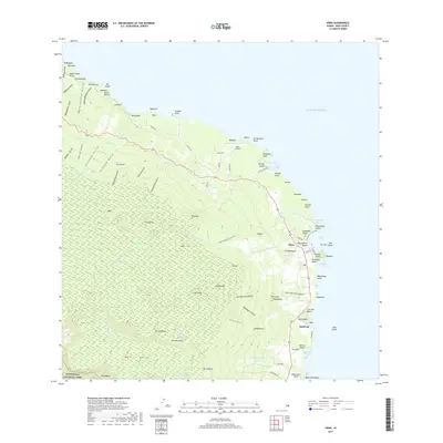
2017 Map of Hana
USGS Topo · Published 2017About this map
Haleakala National Park defines the southwestern reaches of this East Maui landscape, where the volcanic slopes of the island descend toward the Pacific Ocean. This 2017 survey documents the modern layout of the coastal settlement at Hāna, a historic gateway along the windward coast characterized by its proximity to Hāna Bay and the prominent Kaʻuiki Head. The map detail follows the winding path of the Hana Highway as it connects small communities like Helani and Hōkūʻula while crossing numerous drainage features such as Kawaipapa Stream and Waiohonu Stream.
Find a feature on this map
100 named features on this map. Tap any name to fly to it.
Don’t see what you’re looking for? This feature index may not catch every label — zoom into the map to look around manually.
Map Details
Editions of this 2017 Hana Map
This is the sole edition of this map. No revisions or reprints were ever made.
Other maps of this area

1954 · Maui
USGS Topo · 1:250,000

1957 · Kipahulu
USGS Topo · 1:24,000

1957 · Hana
USGS Topo · 1:24,000

1957 · Nahiku
USGS Topo · 1:24,000

1957 · Kaupo
USGS Topo · 1:24,000

1957 · Keanae
USGS Topo · 1:24,000

1966 · Maui
USGS Topo · 1:250,000

1974 · Maui
USGS Topo · 1:250,000

1978 · Hana
USGS Topo · 1:24,000

1983 · Nahiku
USGS Topo · 1:24,000