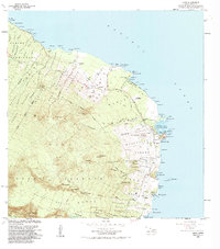
1983 Map of Hana
USGS Topo · Published 1984About this map
The coastal community of Hana serves as the focal point of this east Maui survey, where the Hana Highway winds along the island's steep maritime edge. The geography is defined by a series of homestead districts, including the Nahiku Homesteads and Namoku Homesteads, illustrating the historical division of land for local agricultural use. Along the coast, the map identifies significant sites of cultural and transit history, such as the Mokae Landing and the harbor at Hana Bay, protected by the prominent Kauiki Head. Deep interior conservation is evident in the sprawling Hana Forest Reserve and portions of Haleakala National Park. The landscape is dotted with several notable sites including Ulaino and Honomaele, while modern infrastructure like the Hana Airport and Hana Medical Center mark the 20th-century development of this isolated region.
Find a feature on this map
78 named features on this map. Tap any name to fly to it.
Don’t see what you’re looking for? This feature index may not catch every label — zoom into the map to look around manually.
Map Details
Editions of this 1983 Hana Map
This is the sole edition of this map. No revisions or reprints were ever made.
Other maps of this area

1954 · Maui
USGS Topo · 1:250,000

1957 · Kipahulu
USGS Topo · 1:24,000

1957 · Hana
USGS Topo · 1:24,000

1957 · Nahiku
USGS Topo · 1:24,000

1957 · Kaupo
USGS Topo · 1:24,000

1957 · Keanae
USGS Topo · 1:24,000

1966 · Maui
USGS Topo · 1:250,000

1974 · Maui
USGS Topo · 1:250,000

1978 · Hana
USGS Topo · 1:24,000

1983 · Nahiku
USGS Topo · 1:24,000