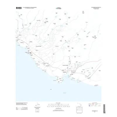
2013 Map of Hanapepe
USGS Topo · Published 2013About this map
Sugar production and coastal navigation define this stretch of southern Kauai, where industrial infrastructure meets the Pacific. The agricultural legacy is anchored by the Olokele Mill and McBryde Mill, supported by a dense network of upland reservoirs like Kaawanui Reservoir and Waikai Reservoir. Settlement patterns reveal the era of plantation life, with a series of numbered camps including Camp Number Three and Camp Number Six clustered near the mills and streams. Along the shore, the maritime activity of Port Allen and the Port Allen Small Boat Harbor sits adjacent to the Port Allen Airport, while the Hanapēpē Light at Puolo Point guides vessels into the bay. From the residential streets of Hanapēpē Heights to the historic Pākalā Village, the landscape reflects a long history of water management, evidenced by the Koula Ditch Tunnel and numerous gulches channeling water toward the coast.
Find a feature on this map
147 named features on this map. Tap any name to fly to it.
Don’t see what you’re looking for? This feature index may not catch every label — zoom into the map to look around manually.
Map Details
Editions of this 2013 Hanapepe Map
This is the sole edition of this map. No revisions or reprints were ever made.
Other maps of this area

1954 · Kauai
USGS Topo · 1:250,000

1963 · Kekaha
USGS Topo · 1:24,000

1963 · Hanapepe
USGS Topo · 1:24,000

1963 · Koloa
USGS Topo · 1:24,000

1965 · Waimea Canyon
USGS Topo · 1:24,000

1965 · Waialeale
USGS Topo · 1:24,000

1967 · Kauai
USGS Topo · 1:250,000

1970 · Kauai
USGS Topo · 1:250,000
1977 · Hanapepe
USGS Topo · 1:24,000
1978 · Koloa
USGS Topo · 1:24,000