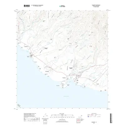
2017 Map of Hanapepe
USGS Topo · Published 2017About this map
Hanapēpē and the surrounding southern coastline of Kauai are defined by a complex network of irrigation reservoirs and deep volcanic valleys. This survey illustrates the intricate water management system serving the region, featuring numerous storage sites such as Kalaeloa Reservoir and A'aka Reservoir, connected by infrastructure like the Koula Ditch Tunnel. The landscape transitions from the dramatic depths of Waimea Canyon in the west to the residential clusters of Kaawanui Village and Pakala Village. Along the shore, maritime and aviation activity centers on Port Allen and the adjacent Port Allen Airport. Inland, the terrain is carved by the Hanapēpē River and Ko'ula River, which flow through heavily dissected valleys like Honua'ula Valley, revealing the geological complexity of the island's interior.
Find a feature on this map
117 named features on this map. Tap any name to fly to it.
Don’t see what you’re looking for? This feature index may not catch every label — zoom into the map to look around manually.
Map Details
Editions of this 2017 Hanapepe Map
This is the sole edition of this map. No revisions or reprints were ever made.
Other maps of this area

1954 · Kauai
USGS Topo · 1:250,000

1963 · Kekaha
USGS Topo · 1:24,000

1963 · Hanapepe
USGS Topo · 1:24,000

1963 · Koloa
USGS Topo · 1:24,000

1965 · Waimea Canyon
USGS Topo · 1:24,000

1965 · Waialeale
USGS Topo · 1:24,000

1967 · Kauai
USGS Topo · 1:250,000

1970 · Kauai
USGS Topo · 1:250,000
1977 · Hanapepe
USGS Topo · 1:24,000
1978 · Koloa
USGS Topo · 1:24,000