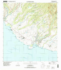
1996 Map of Hanapepe
USGS Topo · Published 1998About this map
Russian Fort Elizabeth State Historical Park anchors the western coast of this Kauai study, marking the historic site where the Waimea River meets the Pacific Ocean near the town of Waimea. The landscape is defined by the sharp transition from the deep coastal valleys like Nonopahu Valley and Kekupua Valley to the organized agricultural and residential layouts of the southern shore. This area, largely under the influence of the Makaweli lands, shows a complex network of irrigation ditches and reservoirs, such as the Waikala Reservoir and Aaka Reservoir, essential for the region's sugar cultivation era.
Find a feature on this map
98 named features on this map. Tap any name to fly to it.
Don’t see what you’re looking for? This feature index may not catch every label — zoom into the map to look around manually.
Map Details
Editions of this 1996 Hanapepe Map
This is the sole edition of this map. No revisions or reprints were ever made.
Other maps of this area

1954 · Kauai
USGS Topo · 1:250,000

1963 · Kekaha
USGS Topo · 1:24,000

1963 · Hanapepe
USGS Topo · 1:24,000

1963 · Koloa
USGS Topo · 1:24,000

1965 · Waimea Canyon
USGS Topo · 1:24,000

1965 · Waialeale
USGS Topo · 1:24,000

1967 · Kauai
USGS Topo · 1:250,000

1970 · Kauai
USGS Topo · 1:250,000
1977 · Hanapepe
USGS Topo · 1:24,000
1978 · Koloa
USGS Topo · 1:24,000