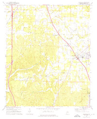
1969 Map of Hanceville
USGS Topo · Published 1976About this map
The Louisville and Nashville railroad corridor anchors the landscape of southern Cullman County, connecting the valley settlements of Hanceville and Garden City. In the late 1960s, this area reflects a classic Piedmont transition from narrow valley agriculture to the wooded uplands of Stout Mountain and Cone Mountain. Local life is organized around a network of country churches and small crossroads, including Good Hope and the Center Community. Higher education and vocational training are represented by the George C Wallace State Trade Sch, while the industrial footprint is visible through a strip mine on the slopes of the mountain and various quarries. The winding courses of Mud Creek and Marriott Creek further define the terrain, illustrating the complex drainage patterns that shaped early settlement and road placement in this part of Alabama.
Find a feature on this map
39 named features on this map. Tap any name to fly to it.
Don’t see what you’re looking for? This feature index may not catch every label — zoom into the map to look around manually.
Map Details
Editions of this 1969 Hanceville Map
4 editions found
Other maps of this area

1888 · Cullman
USGS Topo · 1:125,000

1889 · Birmingham
USGS Topo · 1:125,000

1892 · Cullman
USGS Topo · 1:125,000

1892 · Birmingham
USGS Topo · 1:125,000

1895 · Birmingham
USGS Topo · 1:125,000

1907 · Birmingham
USGS Topo · 1:125,000

1951 · Arkadelphia
USGS Topo · 1:24,000

1951 · Blount Springs
USGS Topo · 1:24,000

1953 · Birmingham
USGS Topo · 1:250,000

1956 · Birmingham
USGS Topo · 1:250,000