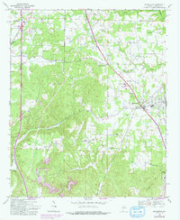
1969 Map of Hanceville
USGS Topo · Published 1993About this map
Hanceville serves as the focal point of this North Alabama survey, positioned along the L & N railroad line as it cuts across the landscape of southern Cullman County. The map documents a transition from the developing municipal centers to the prominent ridgelines of the Appalachian foothills, notably Stout Mountain and Buttermilk Mtn. To the south, Garden City marks the edge of the quadrangle where Garden City Mtn rises above the valley floor.
Find a feature on this map
39 named features on this map. Tap any name to fly to it.
Don’t see what you’re looking for? This feature index may not catch every label — zoom into the map to look around manually.
Map Details
Editions of this 1969 Hanceville Map
4 editions found
Other maps of this area

1888 · Cullman
USGS Topo · 1:125,000

1889 · Birmingham
USGS Topo · 1:125,000

1892 · Cullman
USGS Topo · 1:125,000

1892 · Birmingham
USGS Topo · 1:125,000

1895 · Birmingham
USGS Topo · 1:125,000

1907 · Birmingham
USGS Topo · 1:125,000

1951 · Arkadelphia
USGS Topo · 1:24,000

1951 · Blount Springs
USGS Topo · 1:24,000

1953 · Birmingham
USGS Topo · 1:250,000

1956 · Birmingham
USGS Topo · 1:250,000