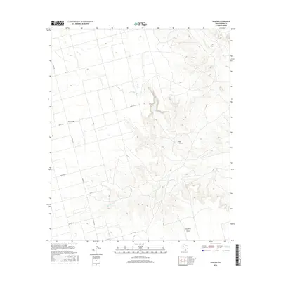
2016 Map of Hancock
USGS Topo · Published 2016About this map
Hancock sits at the intersection of a sprawling rural road network in this high-plains landscape of Dawson County. The terrain is defined by the sharp incisions of Rock Canyon and T J F Draw, which cut through the level ranchlands to the northeast. These geographic features, along with the intermittent courses of Tobacco Cr and Wet Tobacco Cr, reveal the drainage patterns typical of the Texas Panhandle region. The map reflects a modern rural economy where traditional ranching infrastructure meets aviation, most notably at the Benny White Flying Airport. A grid of county roads and ranch-to-market routes, including Ranch Rd 2411 and Ranch Rd 178, provides the primary framework for the scattered settlements and agricultural operations in the area.
Find a feature on this map
15 named features on this map. Tap any name to fly to it.
Don’t see what you’re looking for? This feature index may not catch every label — zoom into the map to look around manually.
Map Details
Editions of this 2016 Hancock Map
This is the sole edition of this map. No revisions or reprints were ever made.
Other maps of this area

1954 · Big Spring
USGS Topo · 1:250,000

1958 · Big Spring
USGS Topo · 1:250,000

1968 · Lamesa North
USGS Topo · 1:24,000

1968 · Hancock
USGS Topo · 1:24,000

1969 · Gooch Lake
USGS Topo · 1:24,000

1969 · O'Donnell
USGS Topo · 1:24,000

1969 · Indian Canyon
USGS Topo · 1:24,000
1970 · Indian Canyon NW
USGS Topo · 1:24,000

1970 · Lamesa South
USGS Topo · 1:24,000

1970 · Key
USGS Topo · 1:24,000