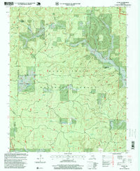
1997 Map of Handy
USGS Topo · Published 1999About this map
Mark Twain National Forest dominates this landscape in the Missouri Ozarks, characterized by a complex network of hollows and karst water features. Centered on the settlement of Handy, the topography is defined by significant drainage systems including Big Barren Creek and Running Water Creek. The presence of Bristol Cemetery and institutions like Handy Church and Big Barren Church provides a clear view of the social fabric in this rural area at the close of the twentieth century. Unique upland water bodies such as Cupola Pond, West Pond, and Flat Pond illustrate the district's karst geography. Historical transportation and logging patterns remain visible through the alignment of Tram Road, while the Ozark Trail and the edge of the Irish Wilderness highlight the region's transition into a protected recreational and conservation corridor.
Find a feature on this map
40 named features on this map. Tap any name to fly to it.
Don’t see what you’re looking for? This feature index may not catch every label — zoom into the map to look around manually.
Map Details
Editions of this 1997 Handy Map
This is the sole edition of this map. No revisions or reprints were ever made.
Other maps of this area

1939 · Doniphan
USGS Topo · 1:62,500

1941 · Gatewood
USGS Topo · 1:62,500

1944 · Van Buren
USGS Topo · 1:62,500

1944 · Grandin
USGS Topo · 1:62,500

1945 · Doniphan
USGS Topo · 1:62,500

1945 · Gatewood
USGS Topo · 1:62,500

1946 · Grandin
USGS Topo · 1:62,500

1946 · Van Buren
USGS Topo · 1:62,500

1957 · Poplar Bluff
USGS Topo · 1:250,000

1959 · Poplar Bluff
USGS Topo · 1:250,000