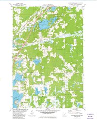
1981 Map of Hanging Horn Lake
USGS Topo · Published 1982About this map
The town of Barnum serves as a northern hub in this detailed look at Carlton and Pine Counties during the early 1980s. The landscape is defined by its glacial lakes, including the distinctive Hanging Horn Lake and the recreational waters of Moose Lake. Transport and industry are evident through the Burlington Northern and Soo Line railroads, alongside active Gravel Pits that suggest a region deeply tied to its physical resources.
Find a feature on this map
60 named features on this map. Tap any name to fly to it.
Don’t see what you’re looking for? This feature index may not catch every label — zoom into the map to look around manually.
Map Details
Editions of this 1981 Hanging Horn Lake Map
This is the sole edition of this map. No revisions or reprints were ever made.
Other maps of this area

1953 · Duluth
USGS Topo · 1:250,000

1954 · Atkinson
USGS Topo · 1:24,000

1956 · Barnum
USGS Topo · 1:62,500

1958 · Duluth
USGS Topo · 1:250,000

1961 · Cromwell
USGS Topo · 1:62,500

1961 · Moose Lake
USGS Topo · 1:62,500

1962 · Bruno
USGS Topo · 1:62,500

1980 · Sandstone
USGS Topo · 1:100,000

1980 · Duluth
USGS Topo · 1:100,000
1981 · Kerrick
USGS Topo · 1:24,000