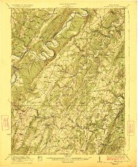
1923 Map of Hanging Rock
USGS Topo · Published 1923About this map
Potomac River South Branch carves a dramatic winding path through the ridges of Hampshire County, anchoring a landscape defined by 1920s Appalachian agriculture and river commerce. This survey captures the transition from water-powered industry to rail-and-road dominance, noting historic sites like Willesons Mill and Barnes Mill alongside the iron rails of the Baltimore and Ohio RR and the South Branch RR. The map records a dense network of mountain communities including Springfield, Three Churches, and North River Mills, each supported by specialized rural infrastructure such as the Queen of Gore School and Haines Store. Travel through the gaps of Mill Creek Mountain and South Branch Mountain is dictated by the old Northwestern Turnpike, providing a detailed look at the settlement patterns of the South Branch Valley before modern highway expansion altered the traditional mountain life.
Find a feature on this map
107 named features on this map. Tap any name to fly to it.
Don’t see what you’re looking for? This feature index may not catch every label — zoom into the map to look around manually.
Map Details
Editions of this 1923 Hanging Rock Map
4 editions found

Other maps of this area

1891 · Romney
USGS Topo · 1:125,000

1894 · Winchester
USGS Topo · 1:125,000

1898 · Frostburg
USGS Topo · 1:62,500

1898 · Paw Paw
USGS Topo · 1:62,500

1899 · Flintstone
USGS Topo · 1:62,500

1900 · Pawpaw
USGS Topo · 1:62,500

1900 · Flintstone
USGS Topo · 1:62,500

1901 · Frostburg
USGS Topo · 1:62,500

1908 · Frostburg
USGS Topo · 1:62,500

1910 · Paw Paw
USGS Topo · 1:62,500