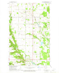
1964 Map of Hanks Corner
USGS Topo · Published 1966About this map
Hanks Corner sits at the intersection of local water management and early 1960s prairie infrastructure, positioned near the Cavalier and Pembina County line. The landscape is defined by the winding paths of the Little South Pembina River and the Tongue River, supplemented by a series of small-scale water projects such as Herzog Dam, Goschke Dam, and Bourbanis Dam. These features illustrate the mid-century efforts to manage drainage and irrigation across the townships of North Olga, South Olga, La Moure, and Beaulieu.
Find a feature on this map
25 named features on this map. Tap any name to fly to it.
Don’t see what you’re looking for? This feature index may not catch every label — zoom into the map to look around manually.
Map Details
Editions of this 1964 Hanks Corner Map
This is the sole edition of this map. No revisions or reprints were ever made.
Other maps of this area

1918 · Walhalla
USGS Topo · 1:62,500

1943 · Walhalla
USGS Topo · 1:62,500

1952 · Thief River Falls
USGS Topo · 1:250,000

1953 · Devils Lake
USGS Topo · 1:250,000

1956 · Thief River Falls
USGS Topo · 1:250,000

1956 · Devils Lake
USGS Topo · 1:250,000

1957 · Thief River Falls
USGS Topo · 1:250,000

1964 · Mountain
USGS Topo · 1:24,000

1964 · Hallson
USGS Topo · 1:24,000

1964 · Leroy
USGS Topo · 1:24,000