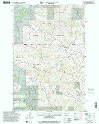
1997 Map of Hanks Gully
USGS Topo · Published 2001About this map
The Little Missouri River carves through the landscape of the Little Missouri National Grassland, defining a region shaped by both its prehistoric geology and modern energy extraction. During the late 1990s, this area of western North Dakota supported a complex network of industrial and agricultural activity, evidenced by the Little Missouri Oil Field and the neighboring Rough Rider Oil Field. A compressor station serves as a focal point for the infrastructure required to manage these resources.
Find a feature on this map
24 named features on this map. Tap any name to fly to it.
Don’t see what you’re looking for? This feature index may not catch every label — zoom into the map to look around manually.
Map Details
Editions of this 1997 Hanks Gully Map
This is the sole edition of this map. No revisions or reprints were ever made.
Other maps of this area

1953 · Watford City
USGS Topo · 1:250,000

1957 · Watford City
USGS Topo · 1:250,000

1963 · Gorham NW
USGS Topo · 1:24,000

1967 · Watford City
USGS Topo · 1:250,000

1970 · Eagle Draw
USGS Topo · 1:24,000

1970 · Hanks Gully
USGS Topo · 1:24,000

1970 · Roosevelt Creek East
USGS Topo · 1:24,000

1974 · Wolf Coulee
USGS Topo · 1:24,000

1974 · Squaretop Butte
USGS Topo · 1:24,000

1974 · Roosevelt Creek West
USGS Topo · 1:24,000