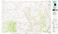
1980 Map of Hanksville
USGS Topo · Published 1987About this map
Hanksville serves as the central hub for this expansive high-desert region, situated at the confluence of the Fremont River and Muddy Creek. The landscape transition is stark, moving from the jagged peaks of the Henry Mountains and Mt Ellen Peak in the southwest to the broad, arid reaches of the San Rafael Desert to the north. Industrial activity is represented by the Factory Butte Mine near the prominent landmark of Factory Butte.
Find a feature on this map
81 named features on this map. Tap any name to fly to it.
Don’t see what you’re looking for? This feature index may not catch every label — zoom into the map to look around manually.
Map Details
Editions of this 1980 Hanksville Map
2 editions found
Other maps of this area

1885 · San Rafael
USGS Topo · 1:250,000

1885 · La Sal
USGS Topo · 1:250,000

1885 · Fish Lake
USGS Topo · 1:250,000

1886 · Escalante
USGS Topo · 1:250,000

1886 · Henry Mountains
USGS Topo · 1:250,000

1886 · Abajo
USGS Topo · 1:250,000

1892 · Abajo
USGS Topo · 1:250,000

1892 · Henry Mountains
USGS Topo · 1:250,000

1893 · Abajo
USGS Topo · 1:250,000

1896 · Fish Lake
USGS Topo · 1:250,000