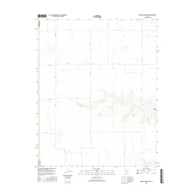
2016 Map of Hannas Draw West
USGS Topo · Published 2016About this map
Hannas Draw carves a distinct path through the High Plains along the border of Sherman Co and Hansford Co. This portion of the Texas Panhandle is defined by a grid of agricultural transit routes, including Farm Rd 1573 and Fm 2018, which facilitate the movement of goods through this sparsely populated ranching and farming landscape. The topography is largely level except where the drainage of the draw creates intricate contouring in the southeastern quadrant. Local infrastructure is represented by a network of county roads such as Co Rd 4 and Co Rd 7, alongside specialized names like Usa Rd, reflecting the modern logistical character of this borderland region between Sherman and Hansford counties.
Find a feature on this map
14 named features on this map. Tap any name to fly to it.
Don’t see what you’re looking for? This feature index may not catch every label — zoom into the map to look around manually.
Map Details
Editions of this 2016 Hannas Draw West Map
This is the sole edition of this map. No revisions or reprints were ever made.
Other maps of this area

1954 · Perryton
USGS Topo · 1:250,000

1958 · Perryton
USGS Topo · 1:250,000

1972 · Capps Switch
USGS Topo · 1:24,000

1973 · Gruver
USGS Topo · 1:24,000

1974 · Morse
USGS Topo · 1:24,000

1974 · Hannas Draw East
USGS Topo · 1:24,000
1974 · Capps Switch SE
USGS Topo · 1:24,000

1974 · Sunray 1 SW
USGS Topo · 1:24,000

1974 · Sunray 1 SE
USGS Topo · 1:24,000

1974 · Capps Switch NW
USGS Topo · 1:24,000